Cercocarpus betuloides range map
Description:
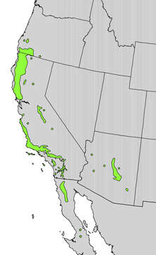
: All biogeographical map images in this gallery could be re-created using vector graphics as SVG files. This has several advantages; see Commons:Media for cleanup for more information. If an SVG form of this image is available, please upload it and afterwards replace this template with {{vector version available|new image name}}. Description: English: Range map of Cercocarpus betuloides. Date: 1999. Source: Digital representation of "Atlas of United States Trees" by Elbert L. Little, Jr. [1]. Author: U.S. Geological Survey. This image contains regular noise, texture, or interference which should be cleaned up using Fourier analysis or some similar appropriate method. Beginning with a higher resolution image may help. čeština ∙ English ∙ français ∙ русский ∙ македонски ∙ +/−.
Included On The Following Pages:
- Life (creatures)
- Cellular (cellular organisms)
- Eukaryota (eukaryotes)
- Archaeplastida (plants)
- Chloroplastida (green plants)
- Streptophyta
- Embryophytes
- Tracheophyta (ferns)
- Spermatophytes (seed plants)
- Angiosperms (Dicotyledons)
- Eudicots
- Superrosids
- Rosids
- Rosales ("Order: Roses, Figs, Nettles & relatives")
- Rosaceae (rose family)
- Cercocarpus (mountain mahogany)
- Cercocarpus montanus (alderleaf mountain mahogany)
- Cercocarpus montanus glaber (Birch-leaf Mountain-mahogany)
This image is not featured in any collections.
Source Information
- license
- cc-publicdomain
- creator
- U.S. Geological Survey
- source
- Digital representation of "Atlas of United States Trees" by Elbert L. Little, Jr. [1]
- original
- original media file
- visit source
- partner site
- Wikimedia Commons
- ID