Shaded Area Distribution Map for Thrasops occidentalis
Description:
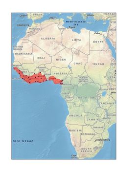
Shaded Area Distribution Map for Thrasops occidentalis
This is a shaded area map for the species Thrasops occidentalis from gps coordinate data from Dr. Kate Jackson. Please note that the boundaries are only rough approximations based on vegetation, altitude, and geographic entities (i.e. mountain ranges, streams, etc.).
Included On The Following Pages:
- Life (creatures)
- Cellular (cellular organisms)
- Eukaryota (eukaryotes)
- Opisthokonta (opisthokonts)
- Metazoa (Animal)
- Bilateria
- Deuterostomia (deuterostomes)
- Chordata (Chordates)
- Vertebrata (vertebrates)
- Gnathostomata (jawed fish)
- Osteichthyes
- Sarcopterygii (Lobe-finned fishes)
- Tetrapoda (terrestrial vertebrates)
- Amniota (amniotes)
- Reptilia (Reptiles)
- Diapsida (diapsid)
- Lepidosauromorpha
- Squamata (lizards and snakes)
- Serpentes (snakes)
- Colubridae (colubrid snakes)
- Thrasops
- Thrasops occidentalis ((Western) Black Tree Snake)
- Lepidosauriformes
- Reptiliomorpha
- Eureptilia
- Neodiapsida
This image is not featured in any collections.
Source Information
- license
- cc-by-nc
- copyright
- Kiskaddon, Erin
- photographer
- Kiskaddon, Erin and Chad Trexler
- publisher
- Kiskaddon, Erin
- provider
- African Snakes of the Genus Thrasops
- original
- original media file
- visit source
- partner site
- Thrasops LifeDesk
- ID