-
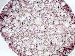
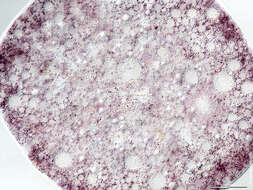
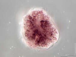
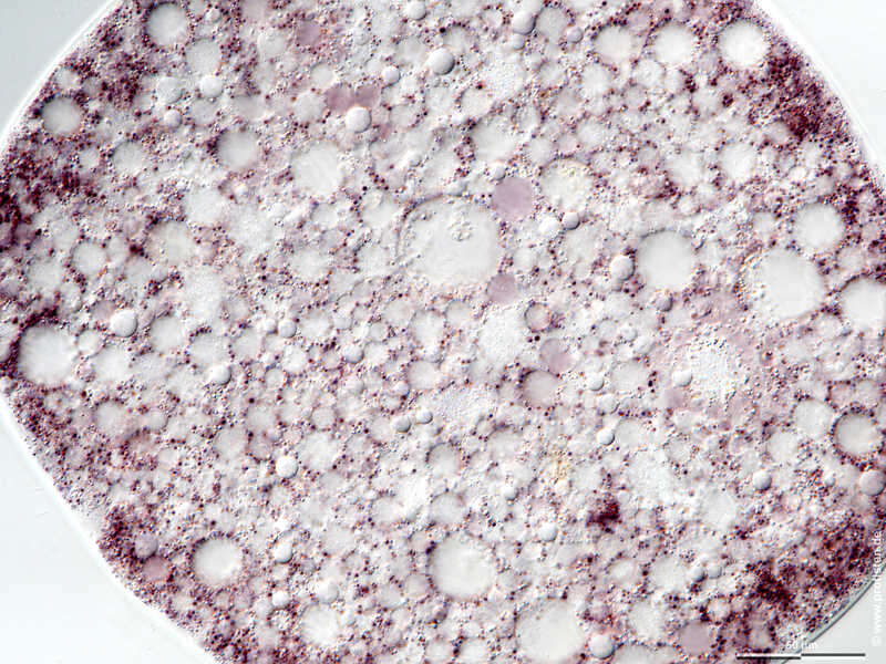
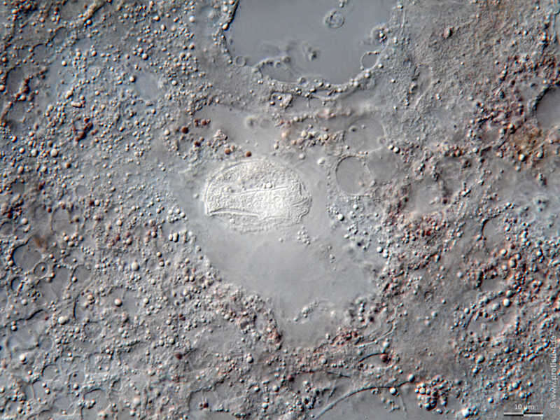
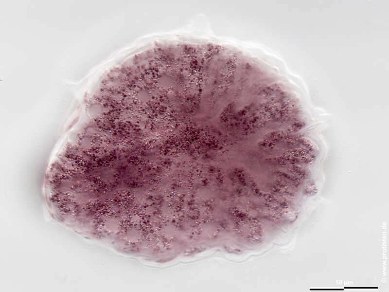
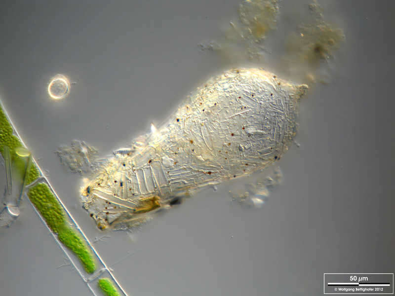
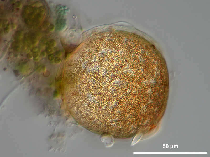
Zonomyxa violacea Scale bar indicates 50 µm. Sample from wetland Lauchseemoor, Fieberbrunn, Tyrol, Austria. Sampling date 06/2023. The image was built up using several photomicrographic frames with manual stacking technique. Images were taken using Zeiss Axioplan with Olympus OM-D M5 MKII. Image under Creative Commons License V 3.0 (CC BY-NC-SA). Place name: Wetland Lauchseemoor, Fieberbrunn (Tyrol, Austria) Latitude: 47.46954439 Longitude: 12.53826499 Multiebenen-Abbildung, manuell gestapelt. Der Messbalken markiert eine Länge von 50 µm. Probe aus dem Lauchseemoor bei Fieberbrunn, Tirol. Datum der Aufsammlung: 06/2023. Mikrotechnik: Zeiss Axioplan, Kamera: Olympus OM-D M5 MKII. Creative Commons License V 3.0 (CC BY-NC-SA). For permission to use of (high-resolution) images please contact postmaster@protisten.de.
-
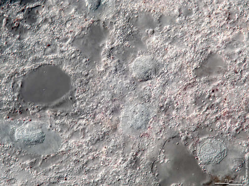
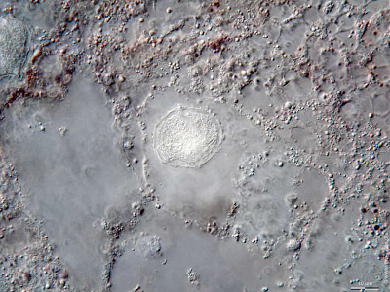
Zonomyxa violacea Detail: Area with nuclei. The nuclear envelopes are clearly visible. Scale bar indicates 25 µm. Sample from wetland Lauchseemoor, Fieberbrunn, Tyrol, Austria. Sampling date 06/2023. The image was built up using several photomicrographic frames with manual stacking technique. Images were taken using Zeiss Axioplan with Olympus OM-D M5 MKII. Image under Creative Commons License V 3.0 (CC BY-NC-SA). Place name: Wetland Lauchseemoor, Fieberbrunn (Tyrol, Austria) Latitude: 47.46954439 Longitude: 12.53826499 Ausschnitt: Bereich der Zellkerne. Die Kernmembran ist jeweils deutlich zu sehen. Multiebenen-Abbildung, manuell gestapelt. Der Messbalken markiert eine Länge von 25 µm. Probe aus dem Lauchseemoor bei Fieberbrunn, Tirol. Datum der Aufsammlung: 06/2023. Mikrotechnik: Zeiss Axioplan, Kamera: Olympus OM-D M5 MKII. Creative Commons License V 3.0 (CC BY-NC-SA). For permission to use of (high-resolution) images please contact postmaster@protisten.de.
-
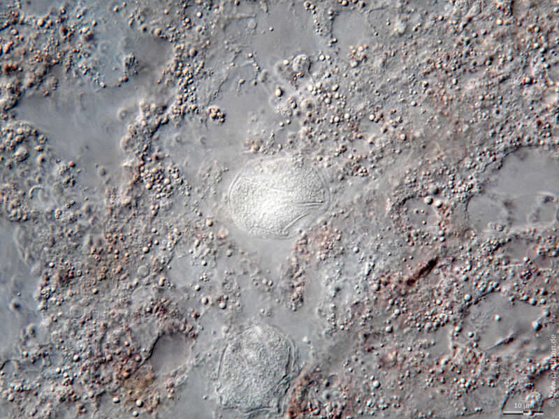
Zonomyxa violacea Detail: Area with nucleus. The nuclear envelopes are clearly visible. Scale bar indicates 10 µm. Sample from wetland Lauchseemoor, Fieberbrunn, Tyrol, Austria. Sampling date 06/2023. The image was built up using several photomicrographic frames with manual stacking technique. Images were taken using Zeiss Axioplan with Olympus OM-D M5 MKII. Image under Creative Commons License V 3.0 (CC BY-NC-SA). Place name: Wetland Lauchseemoor, Fieberbrunn (Tyrol, Austria) Latitude: 47.46954439 Longitude: 12.53826499 Ausschnitt: Bereich mit Zellkern. Die Kernmembran ist jeweils deutlich zu sehen. Multiebenen-Abbildung, manuell gestapelt. Der Messbalken markiert eine Länge von 10 µm. Probe aus dem Lauchseemoor bei Fieberbrunn, Tirol. Datum der Aufsammlung: 06/2023. Mikrotechnik: Zeiss Axioplan, Kamera: Olympus OM-D M5 MKII. Creative Commons License V 3.0 (CC BY-NC-SA). For permission to use of (high-resolution) images please contact postmaster@protisten.de.
-

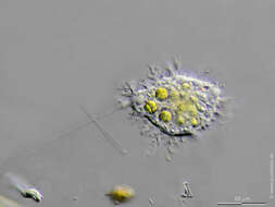
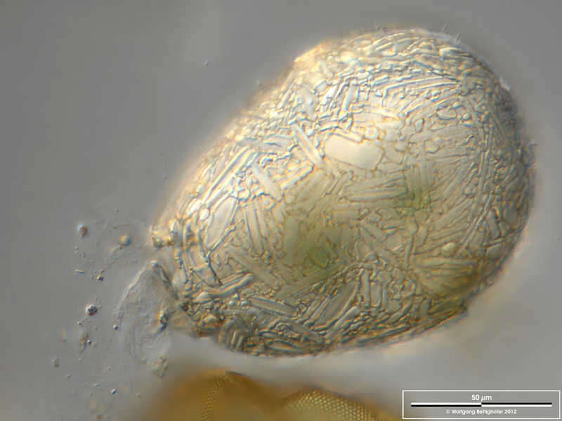
Zonomyxa violacea Detail. The arrow indicates a fibrous structure that belongs to the chitinous shell. This shell type is characteristic of the taxonomic group Corycidia, which includes this species. Scale bar indicates 10 µm. Sample from wetland Lauchseemoor, Fieberbrunn, Tyrol, Austria. Sampling date 06/2023. The image was built up using several photomicrographic frames with manual stacking technique. Images were taken using Zeiss Axioplan with Olympus OM-D M5 MKII. Image under Creative Commons License V 3.0 (CC BY-NC-SA). Place name: Wetland Lauchseemoor, Fieberbrunn (Tyrol, Austria) Latitude: 47.46954439 Longitude: 12.53826499 Ausschnitt. Der Pfeil deutet auf eine faserige Struktur hin, die zur chitinösen Hülle gehört. Dieser Hüllentyp ist charakteristische für die taxonomische Gruppe Corycidia, der diese Art. Multiebenen-Abbildung, manuell gestapelt. Der Messbalken markiert eine Länge von 10 µm. Probe aus dem Lauchseemoor bei Fieberbrunn, Tirol. Datum der Aufsammlung: 06/2023. Mikrotechnik: Zeiss Axioplan, Kamera: Olympus OM-D M5 MKII. Creative Commons License V 3.0 (CC BY-NC-SA). For permission to use of (high-resolution) images please contact postmaster@protisten.de.
-
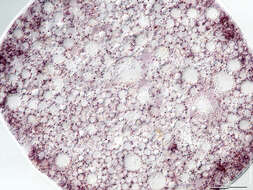
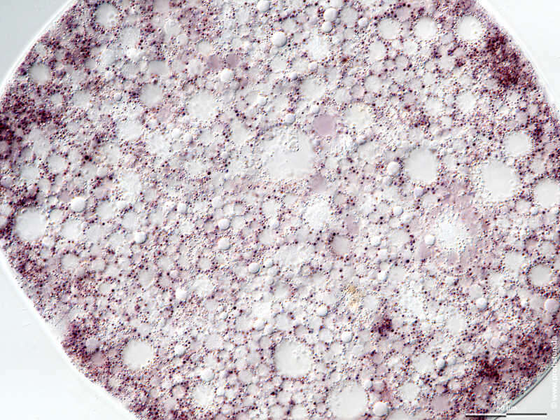
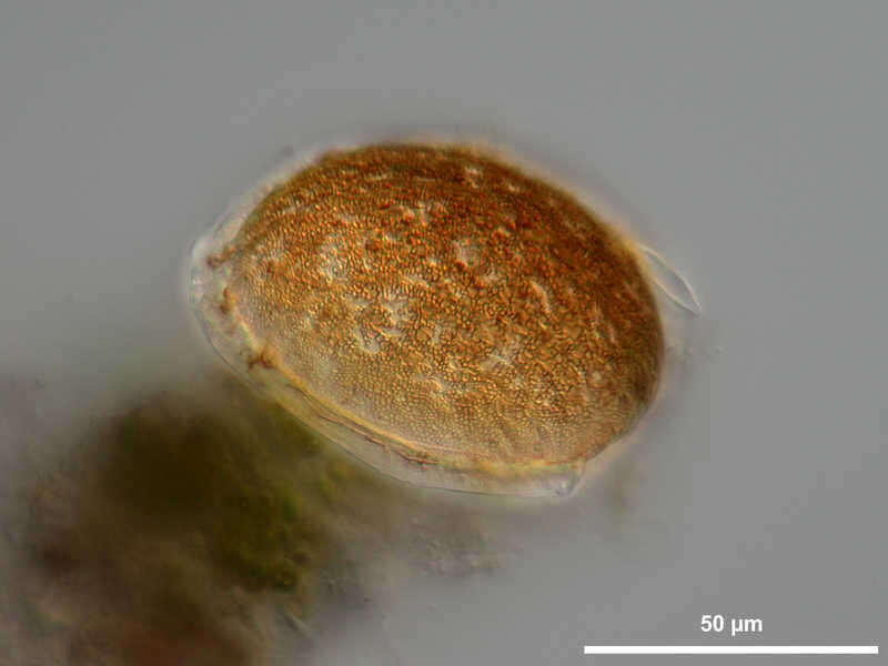
Zonomyxa violacea Scale bar indicates 50 µm. Sample from wetland Lauchseemoor, Fieberbrunn, Tyrol, Austria. Sampling date 06/2023. The image was built up using several photomicrographic frames with manual stacking technique. Images were taken using Zeiss Axioplan with Olympus OM-D M5 MKII. Image under Creative Commons License V 3.0 (CC BY-NC-SA). Place name: Wetland Lauchseemoor, Fieberbrunn (Tyrol, Austria) Latitude: 47.46954439 Longitude: 12.53826499 Multiebenen-Abbildung, manuell gestapelt. Der Messbalken markiert eine Länge von 50 µm. Probe aus dem Lauchseemoor bei Fieberbrunn, Tirol. Datum der Aufsammlung: 06/2023. Mikrotechnik: Zeiss Axioplan, Kamera: Olympus OM-D M5 MKII. Creative Commons License V 3.0 (CC BY-NC-SA). For permission to use of (high-resolution) images please contact postmaster@protisten.de.
-
Zonomyxa violacea Detail: Area with nucleus. The nuclear envelopes are clearly visible. Scale bar indicates 10 µm. Sample from wetland Lauchseemoor, Fieberbrunn, Tyrol, Austria. Sampling date 06/2023. The image was built up using several photomicrographic frames with manual stacking technique. Images were taken using Zeiss Axioplan with Olympus OM-D M5 MKII. Image under Creative Commons License V 3.0 (CC BY-NC-SA). Place name: Wetland Lauchseemoor, Fieberbrunn (Tyrol, Austria) Latitude: 47.46954439 Longitude: 12.53826499 Ausschnitt: Bereich mit Zellkern. Die Kernmembran ist jeweils deutlich zu sehen. Multiebenen-Abbildung, manuell gestapelt. Der Messbalken markiert eine Länge von 10 µm. Probe aus dem Lauchseemoor bei Fieberbrunn, Tirol. Datum der Aufsammlung: 06/2023. Mikrotechnik: Zeiss Axioplan, Kamera: Olympus OM-D M5 MKII. Creative Commons License V 3.0 (CC BY-NC-SA). For permission to use of (high-resolution) images please contact postmaster@protisten.de.
-
Zonomyxa violacea Scale bar indicates 50 µm. Sample from wetland Lauchseemoor, Fieberbrunn, Tyrol, Austria. Sampling date 06/2023. The image was built up using several photomicrographic frames with manual stacking technique. Images were taken using Zeiss Axioplan with Olympus OM-D M5 MKII. Image under Creative Commons License V 3.0 (CC BY-NC-SA). Place name: Wetland Lauchseemoor, Fieberbrunn (Tyrol, Austria) Latitude: 47.46954439 Longitude: 12.53826499 Multiebenen-Abbildung, manuell gestapelt. Der Messbalken markiert eine Länge von 50 µm. Probe aus dem Lauchseemoor bei Fieberbrunn, Tirol. Datum der Aufsammlung: 06/2023. Mikrotechnik: Zeiss Axioplan, Kamera: Olympus OM-D M5 MKII. Creative Commons License V 3.0 (CC BY-NC-SA). For permission to use of (high-resolution) images please contact postmaster@protisten.de.
-
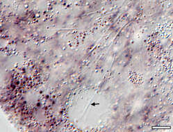
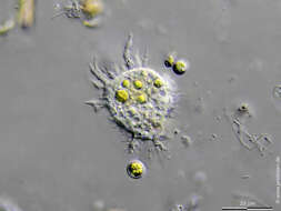
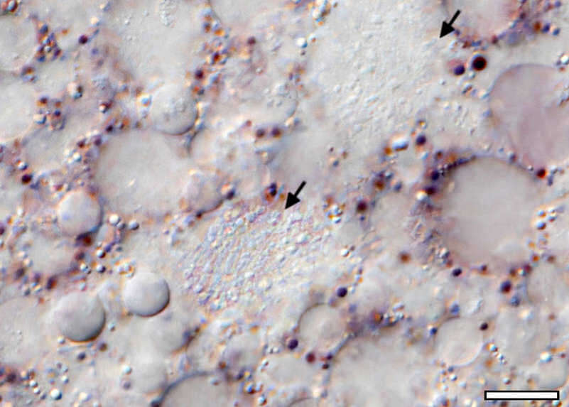
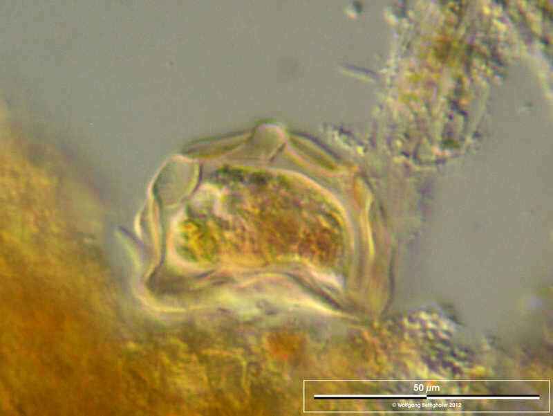
Zonomyxa violacea Detail. The cells contain multiple nuclei (arrows). Scale bar indicates 10 µm. Sample from wetland Lauchseemoor, Fieberbrunn, Tyrol, Austria. Sampling date 06/2023. The image was built up using several photomicrographic frames with manual stacking technique. Images were taken using Zeiss Axioplan with Olympus OM-D M5 MKII. Image under Creative Commons License V 3.0 (CC BY-NC-SA). Place name: Wetland Lauchseemoor, Fieberbrunn (Tyrol, Austria) Latitude: 47.46954439 Longitude: 12.53826499 Ausschnitt. Die Zellen sind mehrkernig (Pfeile). Multiebenen-Abbildung, manuell gestapelt. Der Messbalken markiert eine Länge von 10 µm. Probe aus dem Lauchseemoor bei Fieberbrunn, Tirol. Datum der Aufsammlung: 06/2023. Mikrotechnik: Zeiss Axioplan, Kamera: Olympus OM-D M5 MKII. Creative Commons License V 3.0 (CC BY-NC-SA). For permission to use of (high-resolution) images please contact postmaster@protisten.de.
-
Difflugia ventricosa Scale bar indicates 50 µm. Collected from a freshwater pond on the isle of Hiddensee (German Baltic Sea). The image was built up using several photomicrographic frames with manual stacking technique. The images were taken using Zeiss Universal with Olympus C7070 CCD camera.Image under Creative Commons License V 3.0 (CC BY-NC-SA). Place name: Pond Suploch, Hiddensee (Germany) Latitude: 54.538638 Longitude: 13.097802 Multiebenen-Abbildung, manuell gestapelt. Der Messbalken markiert eine Länge von 50 µm. Probe aus einem kleinen Süßwasserteich auf der Insel Hiddensee, welcher eine faszinierende Vielfalt von nackten und beschalten Amöben beherbergt. Dieses Bild wurde mit Zeiss Universal mit Olympus C7070 CCD-Kamera. Bild unter der Creative Commons Lizenz V 3.0 (CC BY-NC-SA). For permission to use of (high-resolution) images please contact postmaster@protisten.de.
-
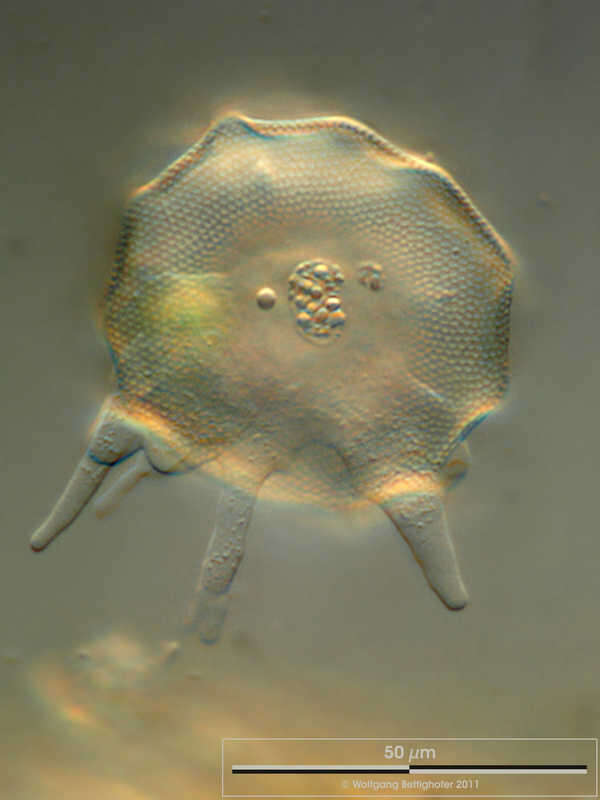
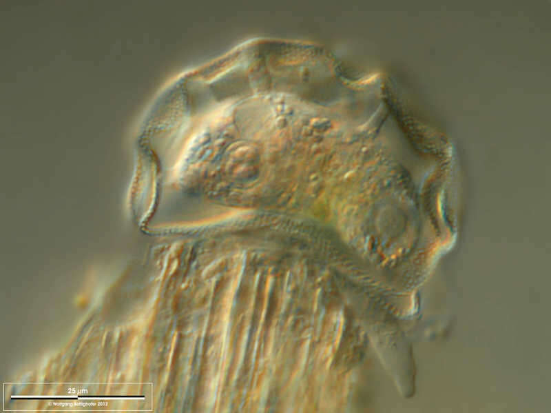
Nebela tincta Scale bar indicates 25 µm. Sample from Grünbichel wetland near Pillersee (Tyrol, Austria). The image was built up using several photomicrographic frames with manual stacking technique. Images were taken using Zeiss Universal with Canon EOS 600D.Image under Creative Commons License V 3.0 (CC BY-NC-SA). Place name: Wetland at the Pillersee (Tyrol, Austria) Latitude: 47.531785 Longitude: 12.573095 Multiebenen-Abbildung, manuell gestapelt. Der Messbalken markiert eine Länge von 25 µm. Probe aus einer Feuchtwiese bei Grünbichel Nähe Pillersee in Tirol. Mikrotechnik: Zeiss Universal, Kamera: Canon EOS 600D. Creative Commons License V 3.0 (CC BY-NC-SA). For permission to use of (high-resolution) images please contact postmaster@protisten.de.
-
Arcella hemisphaerica Arcella hemisphaerica f. undulata. Scale bar indicates 50 µm. Sample from a pond situated in the vicinity of Lake Constance. The image was built up using several photomicrographic frames with manual stacking technique. Images were taken using Zeiss Universal with Olympus C7070 CCD camera.Image under Creative Commons License V 3.0 (CC BY-NC-SA). Place name: Pond situated in the vicinity of Lake Constance (Germany) Latitude: 47.734945 Longitude: 9.091097 Arcella hemisphaerica f. undulata. Multiebenen-Abbildung, manuell gestapelt. Der Messbalken markiert eine Länge von 50 µm. Probe aus einem Teich nahe Bodman (Bodensee). Mikrotechnik: Zeiss Universal, Kamera: Olympus C7070. Creative Commons License V 3.0 (CC BY-NC-SA). For permission to use of (high-resolution) images please contact postmaster@protisten.de.
-
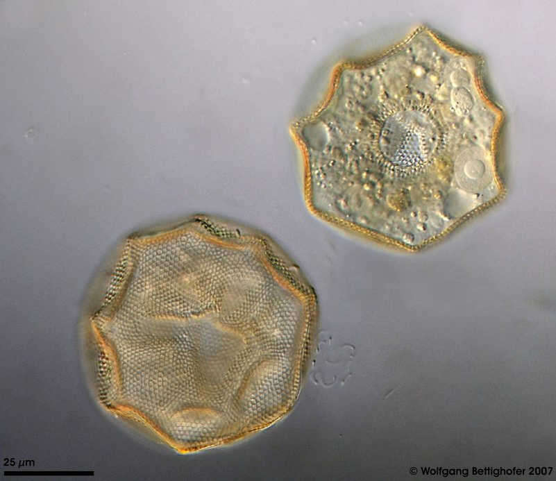
Arcella hemisphaerica Arcella hemisphaerica f. undulata. This testate amoeba constructs a proteinaceous shell with numerous tiny alveoli reinforcing the test. The picture shows the test from dorsal and ventral. On the ventral side, the aperture, two contractile vacuoles and one of two nuclei with centric nucleolus are visible. This picture was built up using 25 DIC frames with manual stacking technique. The scale bar indicates 25 µm. Collected from bottom sediments of a rain storage reservoir in Kiel (Schleswig-Holstein, Germany). Images were taken using Zeiss Universal with Olympus C7070 CCD camera.Image under Creative Commons License V 3.0 (CC BY-NC-SA). Place name: Pond Demühlen, rain storage reservoir in Kiel-Russee (Schleswig-Holstein, Germany) Latitude: 54.304095 Longitude: 10.086073 Arcella hemisphaerica f. undulata. Diese Schalenamöbe bildet eine proteinöse Schale mit zahlreichen kleinen, die Schale verstärkenden Hohlräumen (Areolen). Das Bild zeigt Schale von dorsal und ventral. Auf der Ventralseite sind die Öffnung (Pseudostom), zwei kontraktile Vakuolen und einer der beiden Kerne mit mittigem Nucleolus sichtbar. Tiefenschärfe durch Multiebenenabbildung aus 25 Bildebenen, manuell gestapelt. Der Messbalken zeigt 25 µm an. Aus Bodensedimenten eines Regenrückhaltebeckens in Kiel. Mikrotechnik: Zeiss Universal, Kamera: Olympus C7070. Creative Commons License V 3.0 (CC BY-NC-SA). For permission to use of (high-resolution) images please contact postmaster@protisten.de.
-
Arcella hemisphaerica Arcella hemisphaerica f. undulata. Scale bar indicates 50 µm. Sample from the pond Hegne Moor situated in the vicinity of Lake Constance. The image was built up using several photomicrographic frames with manual stacking technique. Images were taken using Zeiss Universal with Olympus C7070 CCD camera.Image under Creative Commons License V 3.0 (CC BY-NC-SA). Place name: Bog Hegne Moor near Lake Constance (Germany) Latitude: 47.718106 Longitude: 9.093974 Arcella hemisphaerica f. undulata. Multiebenen-Abbildung, manuell gestapelt. Der Messbalken markiert eine Länge von 50 µm. Probe aus dem Simmelried nahe Konstanz. Mikrotechnik: Zeiss Universal, Kamera: Olympus C7070. Creative Commons License V 3.0 (CC BY-NC-SA). For permission to use of (high-resolution) images please contact postmaster@protisten.de.
-
Arcella hemisphaerica Arcella hemisphaerica f. undulata. Scale bar indicates 25 µm. Sample from the pond Hegne Moor situated in the vicinity of Lake Constance. The image was built up using several photomicrographic frames with manual stacking technique. Images were taken using Zeiss Universal with Olympus C7070 CCD camera.Image under Creative Commons License V 3.0 (CC BY-NC-SA). Place name: Bog Hegne Moor near Lake Constance (Germany) Latitude: 47.718106 Longitude: 9.093974 Arcella hemisphaerica f. undulata. Multiebenen-Abbildung, manuell gestapelt. Der Messbalken markiert eine Länge von 25 µm. Probe aus dem Simmelried nahe Konstanz. Mikrotechnik: Zeiss Universal, Kamera: Olympus C7070. Creative Commons License V 3.0 (CC BY-NC-SA). For permission to use of (high-resolution) images please contact postmaster@protisten.de.
-
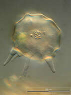
Pyxidicula cymbalum Scale bar indicates 50 µm. Sample from a bog called Simamoor near Pillersee (Tyrol, Austria). The image was built up using several photomicrographic frames with manual stacking technique. Images were taken using Zeiss Axioplan with Canon 600D CCD camera.Image under Creative Commons License V 3.0 (CC BY-NC-SA). Place name: Bog Simamoor near Pillersee (Tyrol, Austria) Latitude: 47.583121 Longitude: 12.617422 Multiebenen-Abbildung, manuell gestapelt. Der Messbalken markiert eine Länge von 50 µm. Probe aus dem Simamoor in der Nähe des Pillersees in Tirol. Mikrotechnik: Zeiss Axioplan, Kamera: Canon 600D. Creative Commons License V 3.0 (CC BY-NC-SA). For permission to use of (high-resolution) images please contact postmaster@protisten.de.
-
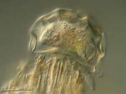
Pyxidicula cymbalum Scale bar indicates 50 µm. Sample from a bog called Simamoor near Pillersee (Tyrol, Austria). The image was built up using several photomicrographic frames with manual stacking technique. Images were taken using Zeiss Axioplan with Canon 600D CCD camera.Image under Creative Commons License V 3.0 (CC BY-NC-SA). Place name: Bog Simamoor near Pillersee (Tyrol, Austria) Latitude: 47.583121 Longitude: 12.617422 Multiebenen-Abbildung, manuell gestapelt. Der Messbalken markiert eine Länge von 50 µm. Probe aus dem Simamoor in der Nähe des Pillersees in Tirol. Mikrotechnik: Zeiss Axioplan, Kamera: Canon 600D. Creative Commons License V 3.0 (CC BY-NC-SA). For permission to use of (high-resolution) images please contact postmaster@protisten.de.
-
Netzelia wailesi Scale bar indicates 50 µm. Collected from a freshwater pond on the isle of Hiddensee (German Baltic Sea). The image was built up using several photomicrographic frames with manual stacking technique. The images were taken using Zeiss Universal with Olympus C7070 CCD camera.Image under Creative Commons License V 3.0 (CC BY-NC-SA). Place name: Pond Suploch, Hiddensee (Germany) Latitude: 54.538638 Longitude: 13.097802 Multiebenen-Abbildung, manuell gestapelt. Der Messbalken markiert eine Länge von 50 µm. Probe aus einem kleinen Süßwasserteich auf der Insel Hiddensee, welcher eine faszinierende Vielfalt von nackten und beschalten Amöben beherbergt. Dieses Bild wurde mit Zeiss Universal mit Olympus C7070 CCD-Kamera. Bild unter der Creative Commons Lizenz V 3.0 (CC BY-NC-SA). For permission to use of (high-resolution) images please contact postmaster@protisten.de.
-
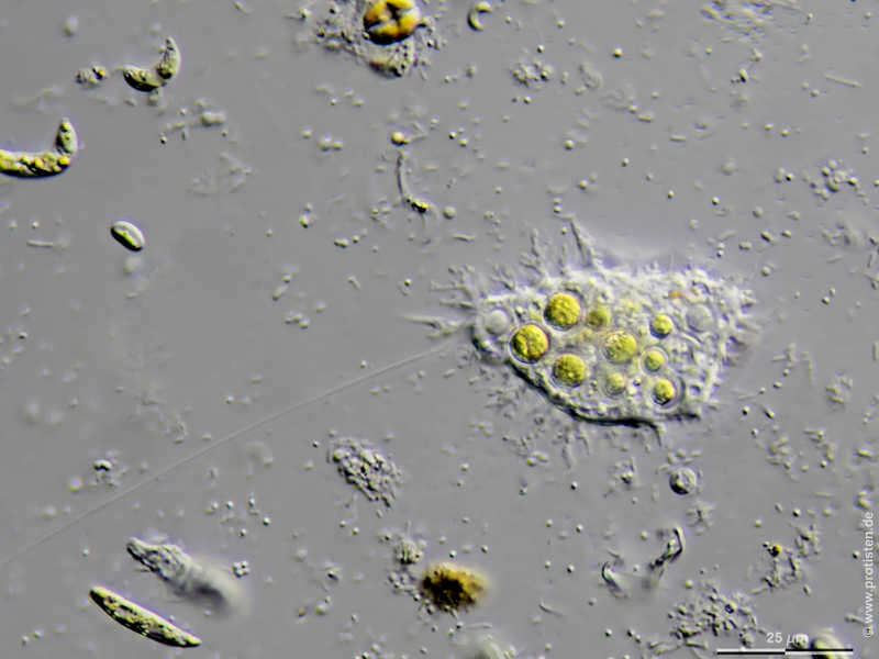
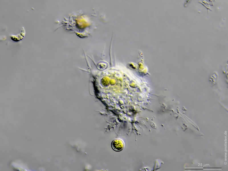
Mastigamoeba aspera Scale bar indicates 25 µm. Collected from a pond near the Bodden bay Schwarzer Peter in the southern part of the isle Hiddensee (German Baltic Sea). Sampling date 10/2018. The image was built up using several photomicrographic frames with manual stacking technique. Images were taken using Zeiss Standard with Olympus OM-D M5 MKII. Image under Creative Commons License V 3.0 (CC BY-NC-SA). Place name: Pond near the Bodden bay Schwarzer Peter, Hiddensee (German Baltic Sea) Latitude: 54.514946 Longitude: 13.082471 Multiebenen-Abbildung, manuell gestapelt. Der Messbalken markiert eine Länge von 25 µm. Probe aus einem Teich nahe der Boddenbucht Schwarzer Peter auf Hiddensee. Datum der Aufsammlung: 10/2018. Mikrotechnik: Zeiss Standard, Kamera: Olympus OM-D M5 MKII. Creative Commons License V 3.0 (CC BY-NC-SA). For permission to use of (high-resolution) images please contact postmaster@protisten.de.
-
Mastigamoeba aspera Scale bar indicates 25 µm. Collected from a pond near the Bodden bay Schwarzer Peter in the southern part of the isle Hiddensee (German Baltic Sea). Sampling date 10/2018. The image was built up using several photomicrographic frames with manual stacking technique. Images were taken using Zeiss Standard with Olympus OM-D M5 MKII. Image under Creative Commons License V 3.0 (CC BY-NC-SA). Place name: Pond near the Bodden bay Schwarzer Peter, Hiddensee (German Baltic Sea) Latitude: 54.514946 Longitude: 13.082471 Multiebenen-Abbildung, manuell gestapelt. Der Messbalken markiert eine Länge von 25 µm. Probe aus einem Teich nahe der Boddenbucht Schwarzer Peter auf Hiddensee. Datum der Aufsammlung: 10/2018. Mikrotechnik: Zeiss Standard, Kamera: Olympus OM-D M5 MKII. Creative Commons License V 3.0 (CC BY-NC-SA). For permission to use of (high-resolution) images please contact postmaster@protisten.de.