-
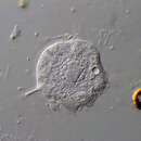
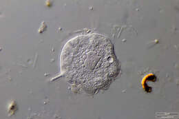
Heliophrya minima Synonym: H. riederi.Scale bar indicates 10 µm. Sample from the wetland called Tegeler Fließ in Berlin. The image was built up using several photomicrographic frames with manual stacking technique. Images were taken using Zeiss Universal with Olympus C7070 CCD camera.Image under Creative Commons License V 3.0 (CC BY-NC-SA). Place name: Wetland Tegeler Fließ, Berlin (Germany) Latitude: 52.623268 Longitude: 13.357816 Synonym: H. riederi.
-
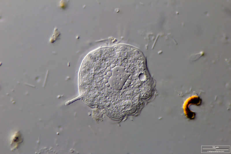
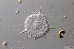
Heliophrya minima Scale bar indicates 25 µm. Sample from a pond situated in the vicinity of Lake Constance. The image was built up using several photomicrographic frames with manual stacking technique. Images were taken using Zeiss Universal with Olympus C7070 CCD camera.Image under Creative Commons License V 3.0 (CC BY-NC-SA). Place name: Pond situated in the vicinity of Lake Constance (Germany) Latitude: 47.734945 Longitude: 9.091097 Multiebenen-Abbildung, manuell gestapelt. Der Messbalken markiert eine Länge von 25 µm. Probe aus einem Teich in der Nähe des Bodensees. Mikrotechnik: Zeiss Universal, Kamera: Olympus C7070. Creative Commons License V 3.0 (CC BY-NC-SA). For permission to use of (high-resolution) images please contact postmaster@protisten.de.
-
Heliophrya minima Synonym: H. riederi.Scale bar indicates 10 µm. Sample from the wetland called Tegeler Fließ in Berlin. The image was built up using several photomicrographic frames with manual stacking technique. Images were taken using Zeiss Universal with Olympus C7070 CCD camera.Image under Creative Commons License V 3.0 (CC BY-NC-SA). Place name: Wetland Tegeler Fließ, Berlin (Germany) Latitude: 52.623268 Longitude: 13.357816 Synonym: H. riederi.
-

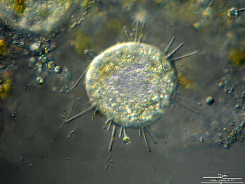
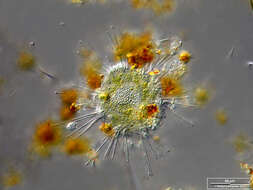
Heliophrya rotunda Nucleus, tufts of tentacles for holding and sucking out the prey. Please press the MORE button for skipping to the annotated version.Scale bar indicates 50 µm. The specimen was gathered in the wetlands of Nationalpark Unteres Odertal (100 km north east of Berlin). Sampling date 5/2022. The image was built up using several photomicrographic frames with manual stacking technique. Images were taken using Zeiss Axioplan with Olympus OM-D M5 MKII. Image under Creative Commons License V 3.0 (CC BY-NC-SA). Place name: Creek in Oder valley 100 km north east of Berlin (Germany) Latitude: 53.135032 Longitude: 14.348738 Zellkern, Tentakelbüschel zum Festhalten und Aussaugen der Beute. Bitte drücken Sie die Schaltfläche MORE, um zur kommentierten Version zu gelangen.Multiebenen-Abbildung, manuell gestapelt. Der Messbalken markiert eine Länge von 50 µm. Probe aus einem Feuchtbiotop im Nationalpark Unteres Odertal auf halber Strecke zwischen Schwedt und Gartz. Datum der Aufsammlung: 7/2022. Mikrotechnik: Zeiss Axioplan, Kamera: Olympus OM-D M5 MKII. Creative Commons License V 3.0 (CC BY-NC-SA). For permission to use of (high-resolution) images please contact postmaster@protisten.de.
-
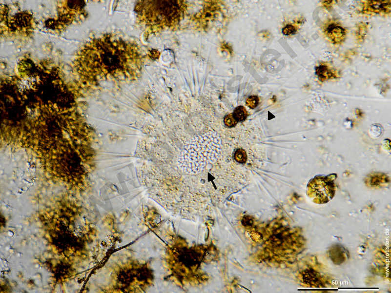
Heliophrya rotunda Nucleus (arrow), tufts of tentacles for holding and sucking out the prey (arrowhead). Scale bar indicates 50 µm. The specimen was gathered in the wetlands of Nationalpark Unteres Odertal (100 km north east of Berlin). Sampling date 5/2022. The image was built up using several photomicrographic frames with manual stacking technique. Images were taken using Zeiss Axioplan with Olympus OM-D M5 MKII. Image under Creative Commons License V 3.0 (CC BY-NC-SA). Place name: Creek in Oder valley 100 km north east of Berlin (Germany) Latitude: 53.135032 Longitude: 14.348738 Zellkern (Pfeil), Tentakelbüschel zum Festhalten und Aussaugen der Beute (Pfeilspitze). Multiebenen-Abbildung, manuell gestapelt. Der Messbalken markiert eine Länge von 50 µm. Probe aus einem Feuchtbiotop im Nationalpark Unteres Odertal auf halber Strecke zwischen Schwedt und Gartz. Datum der Aufsammlung: 7/2022. Mikrotechnik: Zeiss Axioplan, Kamera: Olympus OM-D M5 MKII. Creative Commons License V 3.0 (CC BY-NC-SA). For permission to use of (high-resolution) images please contact postmaster@protisten.de.
-
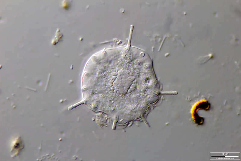
Heliophrya rotunda Scale bar indicates 50 µm. The specimen was gathered in the wetlands of Nationalpark Unteres Odertal (100 km north east of Berlin). The image was built up using several photomicrographic frames with manual stacking technique. Images were taken using Zeiss Axioplan with Olympus OM-D M5 MKII. Image under Creative Commons License V 3.0 (CC BY-NC-SA). Place name: Creek in Oder valley 100 km north east of Berlin (Germany) Latitude: 53.135032 Longitude: 14.348738 Multiebenen-Abbildung, manuell gestapelt. Der Messbalken markiert eine Länge von 50 µm. Probe aus einem Feuchtbiotop im Nationalpark Unteres Odertal auf halber Strecke zwischen Schwedt und Gartz. Mikrotechnik: Zeiss Universal, Kamera: Olympus C7070. Creative Commons License V 3.0 (CC BY-NC-SA). For permission to use of (high-resolution) images please contact postmaster@protisten.de.