-
Oulanka Nationalpark, Kuusamo, Finland
-
Skillingbro kalkgrav, Rold Skov, Danmark
-
Frise, Netherlands
-
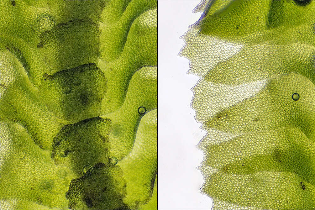
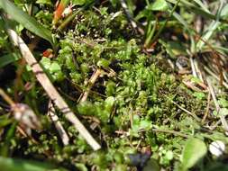
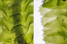
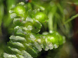
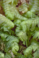
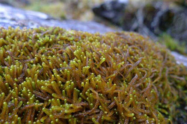
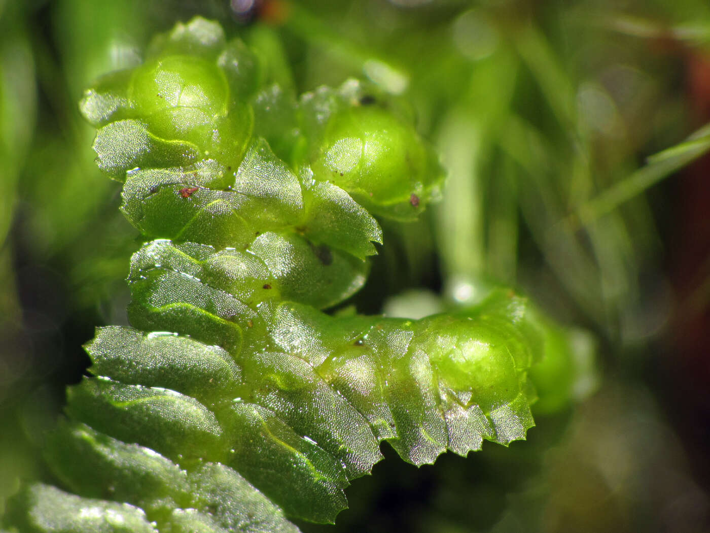
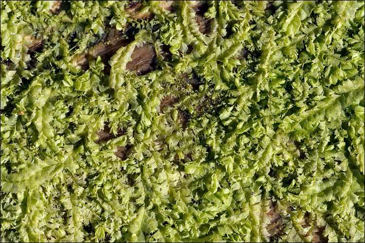
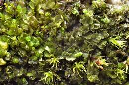
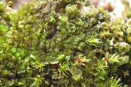
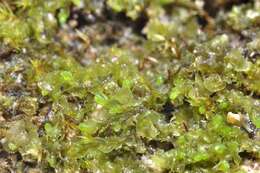
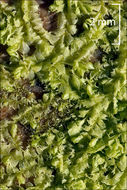
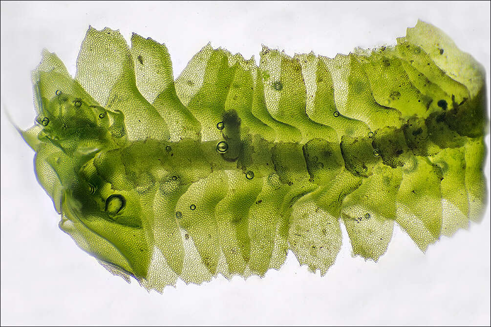
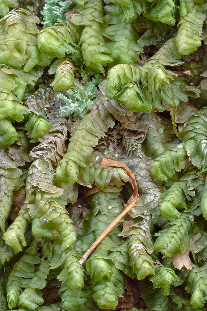
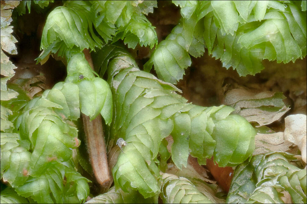
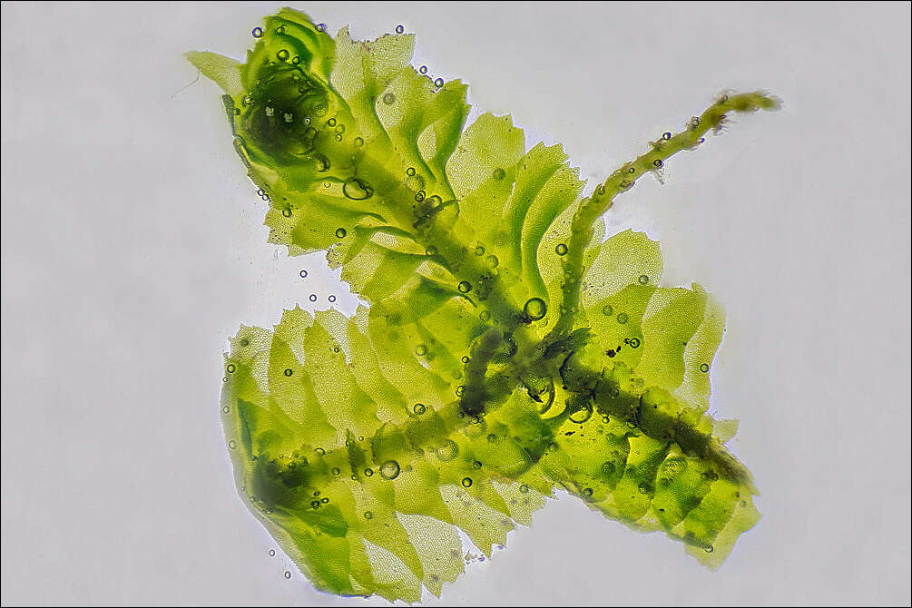
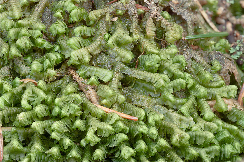
Bazzania trilobata (L.) Gray, syn.: Mastigobryum trilobatum (L.) Nees, Pleuroschisma trilobatum (L.) Dumort., Jungermannia trilobata L.Family: LepidoziaceaeEN: Greater Whipwort, Threelobed bazzania, DE: Grosses Peitschenlebermoos, Dreilappiges PeitschenmoosSlo.: trokrpi binikDat.: Oct. 26. 2021Lat.: 46.39886 Long.: 13.70239Code: Bot_1415/2021_DSC4855Habitat; mixed forest, Fagus sylvatica and Picea abies dominant trees; almost flat terrain, calcareous, old colluvial deposits; locally probably acid ground (understory vegetation mainly Vaccinium myrtillus L.), in shade, partly protected from direct rain by tree canopies, average precipitations ~ 3.000 mm/year, average temperature 4-5 deg C, elevations 1.000 m (3.280 feet), alpine phytogeographical region. Substratum: humus layer on roots of a Picea abies stump in its initial stage of disintegration and on soil among the roots.Place: Upper Trenta valley, Zapodn place, right bank of (dry) Soa river bed, East Julian Alps, Posoje, Slovenia EC. Comments (pertains to pictures in the Flicker album Bazzania trilobata): Bazzania trilobata is a relatively common and among the largest and most noticeable leafy liverworts. Its quite large mats can be found on boggy soils, forest ground, rotten logs, and at the bases of trees. It is a widespread species. Most of others in this genus are more typical of tropical environments. Bazzania trilobata can be recognized by a special arrangement of its leaves. As seen in my close-up photos, the upper edges of the leaves overlap the lower edges of the leaves above them. This is so called incubous leaf arrangement. Most of other leafy liverworts have the opposite arrangement, succubous, where the lower edges of the leaves overlap the upper edges of the leaves below them. Liverworts superficially look similar to mosses. However, apart to other less conspicuous differences, they have differently arranged leaves on the stem. Liverwort leaves are usually arranged in two lateral ranks with a third row of usually much smaller and differently shaped leaves on the back side of the stem (see picture 7a.). Moss leaves have usually a spiral arrangement. If not so, they always lack the third row of the leaves.Ref.:(1) Ian Atherton, Ed., Mosses and Liverworts of Britain and Ireland - a field guide, British Bryological Society (2010), p82. (2) V. Wirth, R. Duell, Farbatlas Flechten und Moose, Ulmer, (2000), p 204.(3) B. Marbach, C. Kainz, Moose, Farne und Flechten, BLV (2002). p 46.(4) W. Rothmaler, Exkursionsflora von Deutschland, Niedere Pflanzen, Band 1, 3.Aufl., Spectrum Akademischer Verlag (2005), p 660.
-
Helsinki, Newland, Finland
-
Skillingbro kalkgrav, Rold Skov, Danmark
-
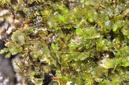
Bazzania trilobata (L.) Gray, syn.: Mastigobryum trilobatum (L.) Nees, Pleuroschisma trilobatum (L.) Dumort., Jungermannia trilobata L.Family: LepidoziaceaeEN: Greater Whipwort, Threelobed bazzania, DE: Grosses Peitschenlebermoos, Dreilappiges PeitschenmoosSlo.: trokrpi binikDat.: Oct. 26. 2021Lat.: 46.39886 Long.: 13.70239Code: Bot_1415/2021_DSC4855Habitat; mixed forest, Fagus sylvatica and Picea abies dominant trees; almost flat terrain, calcareous, old colluvial deposits; locally probably acid ground (understory vegetation mainly Vaccinium myrtillus L.), in shade, partly protected from direct rain by tree canopies, average precipitations ~ 3.000 mm/year, average temperature 4-5 deg C, elevations 1.000 m (3.280 feet), alpine phytogeographical region. Substratum: humus layer on roots of a Picea abies stump in its initial stage of disintegration and on soil among the roots.Place: Upper Trenta valley, Zapodn place, right bank of (dry) Soa river bed, East Julian Alps, Posoje, Slovenia EC. Comments (pertains to pictures in the Flicker album Bazzania trilobata): Bazzania trilobata is a relatively common and among the largest and most noticeable leafy liverworts. Its quite large mats can be found on boggy soils, forest ground, rotten logs, and at the bases of trees. It is a widespread species. Most of others in this genus are more typical of tropical environments. Bazzania trilobata can be recognized by a special arrangement of its leaves. As seen in my close-up photos, the upper edges of the leaves overlap the lower edges of the leaves above them. This is so called incubous leaf arrangement. Most of other leafy liverworts have the opposite arrangement, succubous, where the lower edges of the leaves overlap the upper edges of the leaves below them. Liverworts superficially look similar to mosses. However, apart to other less conspicuous differences, they have differently arranged leaves on the stem. Liverwort leaves are usually arranged in two lateral ranks with a third row of usually much smaller and differently shaped leaves on the back side of the stem (see picture 7a.). Moss leaves have usually a spiral arrangement. If not so, they always lack the third row of the leaves.Ref.:(1) Ian Atherton, Ed., Mosses and Liverworts of Britain and Ireland - a field guide, British Bryological Society (2010), p82. (2) V. Wirth, R. Duell, Farbatlas Flechten und Moose, Ulmer, (2000), p 204.(3) B. Marbach, C. Kainz, Moose, Farne und Flechten, BLV (2002). p 46.(4) W. Rothmaler, Exkursionsflora von Deutschland, Niedere Pflanzen, Band 1, 3.Aufl., Spectrum Akademischer Verlag (2005), p 660.
-
Skillingbro kalkgrav, Rold Skov, Danmark
-
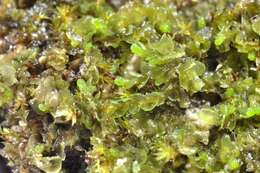
Bazzania trilobata (L.) Gray, syn.: Mastigobryum trilobatum (L.) Nees, Pleuroschisma trilobatum (L.) Dumort., Jungermannia trilobata L.Family: LepidoziaceaeEN: Greater Whipwort, Threelobed bazzania, DE: Grosses Peitschenlebermoos, Dreilappiges PeitschenmoosSlo.: trokrpi binikDat.: Oct. 26. 2021Lat.: 46.39886 Long.: 13.70239Code: Bot_1415/2021_DSC4855Habitat; mixed forest, Fagus sylvatica and Picea abies dominant trees; almost flat terrain, calcareous, old colluvial deposits; locally probably acid ground (understory vegetation mainly Vaccinium myrtillus L.), in shade, partly protected from direct rain by tree canopies, average precipitations ~ 3.000 mm/year, average temperature 4-5 deg C, elevations 1.000 m (3.280 feet), alpine phytogeographical region. Substratum: humus layer on roots of a Picea abies stump in its initial stage of disintegration and on soil among the roots.Place: Upper Trenta valley, Zapodn place, right bank of (dry) Soa river bed, East Julian Alps, Posoje, Slovenia EC. Comments (pertains to pictures in the Flicker album Bazzania trilobata): Bazzania trilobata is a relatively common and among the largest and most noticeable leafy liverworts. Its quite large mats can be found on boggy soils, forest ground, rotten logs, and at the bases of trees. It is a widespread species. Most of others in this genus are more typical of tropical environments. Bazzania trilobata can be recognized by a special arrangement of its leaves. As seen in my close-up photos, the upper edges of the leaves overlap the lower edges of the leaves above them. This is so called incubous leaf arrangement. Most of other leafy liverworts have the opposite arrangement, succubous, where the lower edges of the leaves overlap the upper edges of the leaves below them. Liverworts superficially look similar to mosses. However, apart to other less conspicuous differences, they have differently arranged leaves on the stem. Liverwort leaves are usually arranged in two lateral ranks with a third row of usually much smaller and differently shaped leaves on the back side of the stem (see picture 7a.). Moss leaves have usually a spiral arrangement. If not so, they always lack the third row of the leaves.Ref.:(1) Ian Atherton, Ed., Mosses and Liverworts of Britain and Ireland - a field guide, British Bryological Society (2010), p82. (2) V. Wirth, R. Duell, Farbatlas Flechten und Moose, Ulmer, (2000), p 204.(3) B. Marbach, C. Kainz, Moose, Farne und Flechten, BLV (2002). p 46.(4) W. Rothmaler, Exkursionsflora von Deutschland, Niedere Pflanzen, Band 1, 3.Aufl., Spectrum Akademischer Verlag (2005), p 660.
-
Skillingbro kalkgrav, Rold Skov, Danmark
-
North Carolina, United States
-
Skillingbro kalkgrav, Rold Skov, Danmark
-
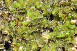
Bazzania trilobata (L.) Gray, syn.: Mastigobryum trilobatum (L.) Nees, Pleuroschisma trilobatum (L.) Dumort., Jungermannia trilobata L.Family: LepidoziaceaeEN: Greater Whipwort, Threelobed bazzania, DE: Grosses Peitschenlebermoos, Dreilappiges PeitschenmoosSlo.: trokrpi binikDat.: Oct. 26. 2021Lat.: 46.39886 Long.: 13.70239Code: Bot_1415/2021_DSC4855Habitat; mixed forest, Fagus sylvatica and Picea abies dominant trees; almost flat terrain, calcareous, old colluvial deposits; locally probably acid ground (understory vegetation mainly Vaccinium myrtillus L.), in shade, partly protected from direct rain by tree canopies, average precipitations ~ 3.000 mm/year, average temperature 4-5 deg C, elevations 1.000 m (3.280 feet), alpine phytogeographical region. Substratum: humus layer on roots of a Picea abies stump in its initial stage of disintegration and on soil among the roots.Place: Upper Trenta valley, Zapodn place, right bank of (dry) Soa river bed, East Julian Alps, Posoje, Slovenia EC. Comments (pertains to pictures in the Flicker album Bazzania trilobata): Bazzania trilobata is a relatively common and among the largest and most noticeable leafy liverworts. Its quite large mats can be found on boggy soils, forest ground, rotten logs, and at the bases of trees. It is a widespread species. Most of others in this genus are more typical of tropical environments. Bazzania trilobata can be recognized by a special arrangement of its leaves. As seen in my close-up photos, the upper edges of the leaves overlap the lower edges of the leaves above them. This is so called incubous leaf arrangement. Most of other leafy liverworts have the opposite arrangement, succubous, where the lower edges of the leaves overlap the upper edges of the leaves below them. Liverworts superficially look similar to mosses. However, apart to other less conspicuous differences, they have differently arranged leaves on the stem. Liverwort leaves are usually arranged in two lateral ranks with a third row of usually much smaller and differently shaped leaves on the back side of the stem (see picture 7a.). Moss leaves have usually a spiral arrangement. If not so, they always lack the third row of the leaves.Ref.:(1) Ian Atherton, Ed., Mosses and Liverworts of Britain and Ireland - a field guide, British Bryological Society (2010), p82. (2) V. Wirth, R. Duell, Farbatlas Flechten und Moose, Ulmer, (2000), p 204.(3) B. Marbach, C. Kainz, Moose, Farne und Flechten, BLV (2002). p 46.(4) W. Rothmaler, Exkursionsflora von Deutschland, Niedere Pflanzen, Band 1, 3.Aufl., Spectrum Akademischer Verlag (2005), p 660.
-
Skillingbro kalkgrav, Rold Skov, Danmark
-

Bazzania trilobata (L.) Gray, syn.: Mastigobryum trilobatum (L.) Nees, Pleuroschisma trilobatum (L.) Dumort., Jungermannia trilobata L.Family: LepidoziaceaeEN: Greater Whipwort, Threelobed bazzania, DE: Grosses Peitschenlebermoos, Dreilappiges PeitschenmoosSlo.: trokrpi binikDat.: Oct. 26. 2021Lat.: 46.39886 Long.: 13.70239Code: Bot_1415/2021_DSC4855Habitat; mixed forest, Fagus sylvatica and Picea abies dominant trees; almost flat terrain, calcareous, old colluvial deposits; locally probably acid ground (understory vegetation mainly Vaccinium myrtillus L.), in shade, partly protected from direct rain by tree canopies, average precipitations ~ 3.000 mm/year, average temperature 4-5 deg C, elevations 1.000 m (3.280 feet), alpine phytogeographical region. Substratum: humus layer on roots of a Picea abies stump in its initial stage of disintegration and on soil among the roots.Place: Upper Trenta valley, Zapodn place, right bank of (dry) Soa river bed, East Julian Alps, Posoje, Slovenia EC. Comments (pertains to pictures in the Flicker album Bazzania trilobata): Bazzania trilobata is a relatively common and among the largest and most noticeable leafy liverworts. Its quite large mats can be found on boggy soils, forest ground, rotten logs, and at the bases of trees. It is a widespread species. Most of others in this genus are more typical of tropical environments. Bazzania trilobata can be recognized by a special arrangement of its leaves. As seen in my close-up photos, the upper edges of the leaves overlap the lower edges of the leaves above them. This is so called incubous leaf arrangement. Most of other leafy liverworts have the opposite arrangement, succubous, where the lower edges of the leaves overlap the upper edges of the leaves below them. Liverworts superficially look similar to mosses. However, apart to other less conspicuous differences, they have differently arranged leaves on the stem. Liverwort leaves are usually arranged in two lateral ranks with a third row of usually much smaller and differently shaped leaves on the back side of the stem (see picture 7a.). Moss leaves have usually a spiral arrangement. If not so, they always lack the third row of the leaves.Ref.:(1) Ian Atherton, Ed., Mosses and Liverworts of Britain and Ireland - a field guide, British Bryological Society (2010), p82. (2) V. Wirth, R. Duell, Farbatlas Flechten und Moose, Ulmer, (2000), p 204.(3) B. Marbach, C. Kainz, Moose, Farne und Flechten, BLV (2002). p 46.(4) W. Rothmaler, Exkursionsflora von Deutschland, Niedere Pflanzen, Band 1, 3.Aufl., Spectrum Akademischer Verlag (2005), p 660.
-
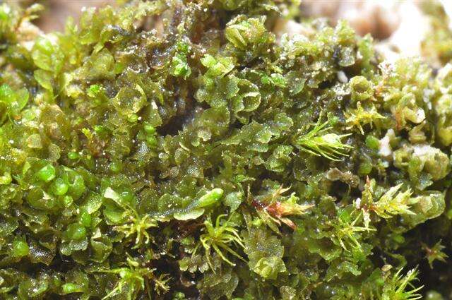
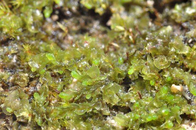
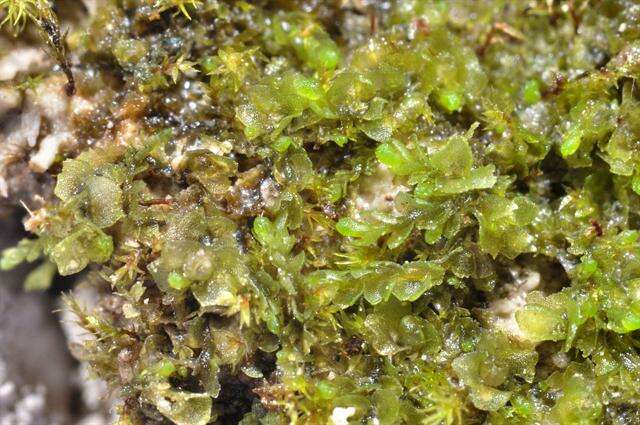
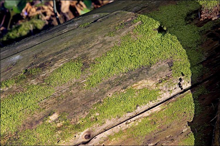
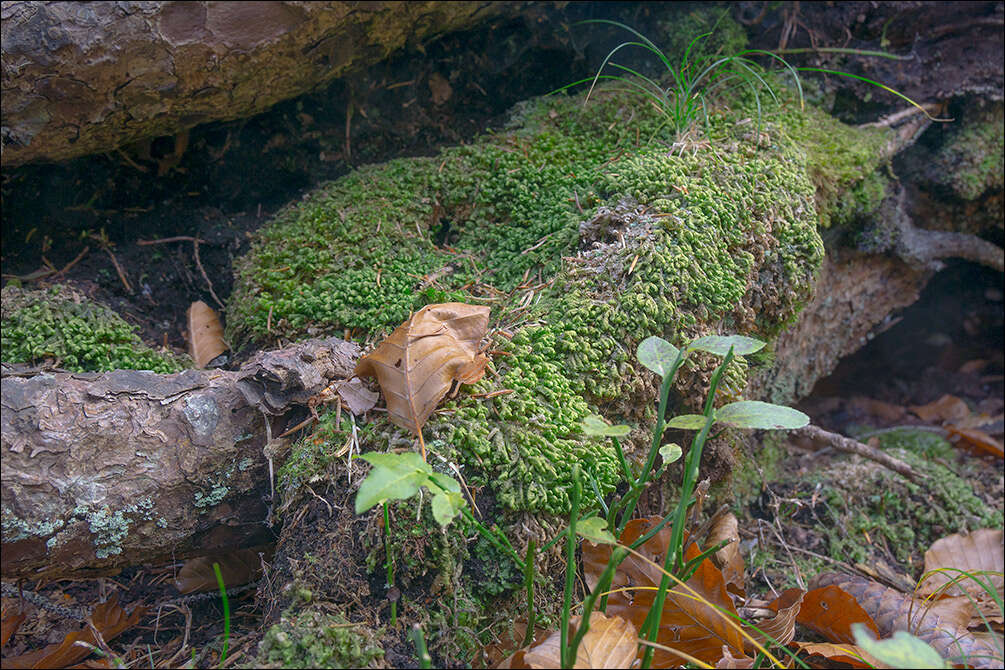
Habitat: Mixed woods, cold mountain stream shore in a narrow alpine valley, shade, humid air, calcareous ground, protected from direct rain by tree canopies, average precipitations ~3.000 mm/year, average temperature 7-9 deg C, elevation 630 m (2,100 feet), alpine phytogeographical region. - Substratum: fallen, debarked, partly rotten trunk of Picea abies. - Comment: Determination not certain. - Ref.: (1) Ian Atherton, Ed. Mosses and Liverworts of Britain and Ireland - a field guide, British Bryological Society (2010), p 92. (2) http://www.geog.ubc.ca/richmond/city/kentcephaloziabicuspidata1.jpg
-
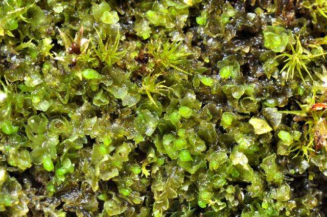
Habitat: Mixed woods, cold mountain stream shore in a narrow alpine valley, shade, humid air, calcareous ground, protected from direct rain by tree canopies, average precipitations ~3.000 mm/year, average temperature 7-9 deg C, elevation 630 m (2,100 feet), alpine phytogeographical region. - Substratum: fallen, debarked, partly rotten trunk of Picea abies. - Comment: Determination not certain. - Ref.: (1) Ian Atherton, Ed. Mosses and Liverworts of Britain and Ireland - a field guide, British Bryological Society (2010), p 92. (2) http://www.geog.ubc.ca/richmond/city/kentcephaloziabicuspidata1.jpg