-
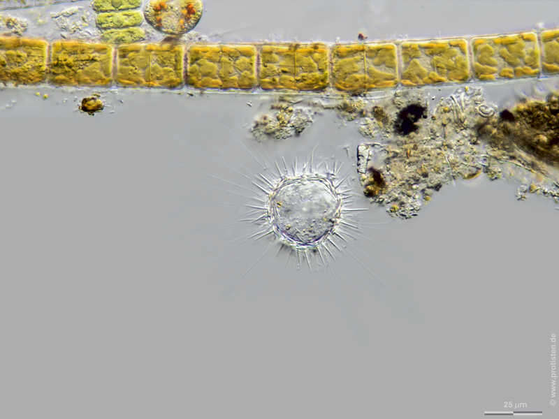
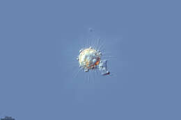
Choanocystis aculeata Scale bar indicates 25 µm. The specimen was gathered in the wetlands of Nationalpark Unteres Odertal (100 km north east of Berlin). Sampling date 5/2019. The image was built up using several photomicrographic frames with manual stacking technique. Images were taken using Zeiss Axioplan with Olympus OM-D M5 MKII. Image under Creative Commons License V 3.0 (CC BY-NC-SA). Place name: Creek in Oder valley 100 km north east of Berlin (Germany) Latitude: 53.135032 Longitude: 14.348738 Multiebenen-Abbildung, manuell gestapelt. Der Messbalken markiert eine Länge von 25 µm. Probe aus einem Feuchtbiotop im Nationalpark Unteres Odertal auf halber Strecke zwischen Schwedt und Gartz. Datum der Aufsammlung: 7/2019. Mikrotechnik: Zeiss Axioplan, Kamera: Olympus OM-D M5 MKII. Creative Commons License V 3.0 (CC BY-NC-SA). For permission to use of (high-resolution) images please contact postmaster@protisten.de.
-
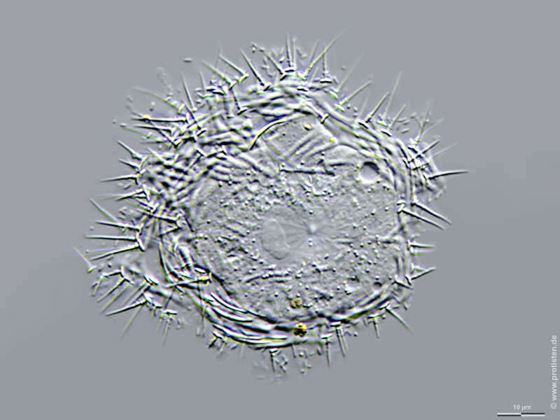
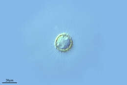
Choanocystis aculeata Spicula of Choanocystis aculeate. Scale bar indicates 10 µm. The specimen was gathered in the wetlands of Nationalpark Unteres Odertal (100 km north east of Berlin). Sampling date 5/2019. The image was built up using several photomicrographic frames with manual stacking technique. Images were taken using Zeiss Axioplan with Olympus OM-D M5 MKII. Image under Creative Commons License V 3.0 (CC BY-NC-SA). Place name: Creek in Oder valley 100 km north east of Berlin (Germany) Latitude: 53.135032 Longitude: 14.348738 Kieselschuppe (Spicula) von Choanocystis aculeate. Multiebenen-Abbildung, manuell gestapelt. Der Messbalken markiert eine Länge von 10 µm. Probe aus einem Feuchtbiotop im Nationalpark Unteres Odertal auf halber Strecke zwischen Schwedt und Gartz. Datum der Aufsammlung: 7/2019. Mikrotechnik: Zeiss Axioplan, Kamera: Olympus OM-D M5 MKII. Creative Commons License V 3.0 (CC BY-NC-SA). For permission to use of (high-resolution) images please contact postmaster@protisten.de.
-
Choanocystis aculeata Scale bar indicates 25 µm. The specimen was gathered in the wetlands of Nationalpark Unteres Odertal (100 km north east of Berlin). Sampling date 5/2019. The image was built up using several photomicrographic frames with manual stacking technique. Images were taken using Zeiss Axioplan with Olympus OM-D M5 MKII. Image under Creative Commons License V 3.0 (CC BY-NC-SA). Place name: Creek in Oder valley 100 km north east of Berlin (Germany) Latitude: 53.135032 Longitude: 14.348738 Multiebenen-Abbildung, manuell gestapelt. Der Messbalken markiert eine Länge von 25 µm. Probe aus einem Feuchtbiotop im Nationalpark Unteres Odertal auf halber Strecke zwischen Schwedt und Gartz. Datum der Aufsammlung: 7/2019. Mikrotechnik: Zeiss Axioplan, Kamera: Olympus OM-D M5 MKII. Creative Commons License V 3.0 (CC BY-NC-SA). For permission to use of (high-resolution) images please contact postmaster@protisten.de.
-
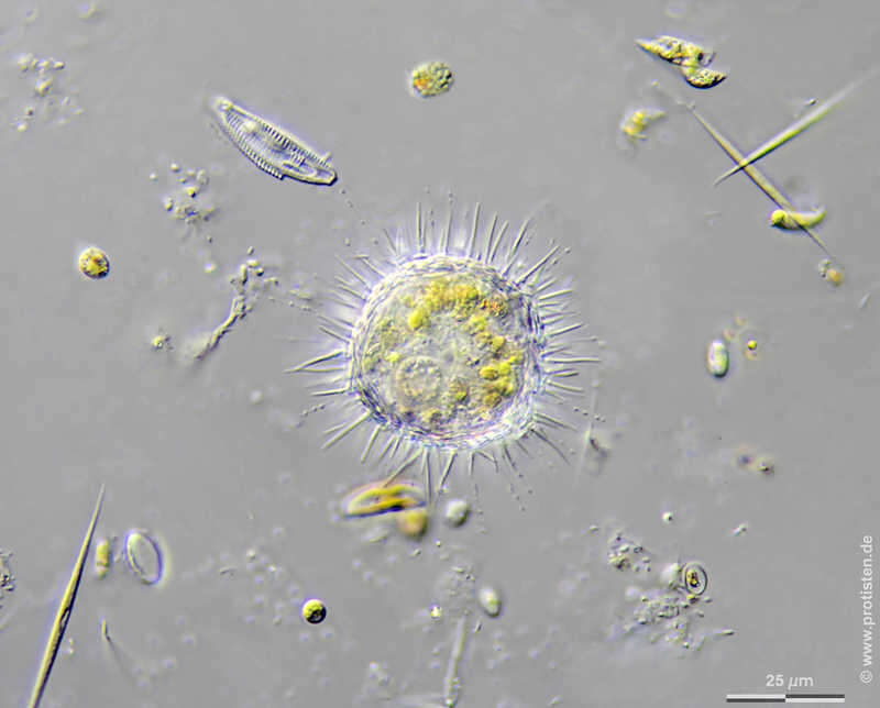
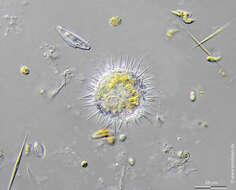
Choanocystis aculeata Scale bar indicates 25 µm. Collected from a pond near the Bodden bay Schwarzer Peter in the southern part of the isle Hiddensee (German Baltic Sea). Sampling date 10/2018. The image was built up using several photomicrographic frames with manual stacking technique. Images were taken using Zeiss Standard with Olympus OM-D M5 MKII. Image under Creative Commons License V 3.0 (CC BY-NC-SA). Place name: Pond near the Bodden bay Schwarzer Peter, Hiddensee (German Baltic Sea) Latitude: 54.514946 Longitude: 13.082471 Multiebenen-Abbildung, manuell gestapelt. Der Messbalken markiert eine Länge von 25 µm. Probe aus einem Teich nahe der Boddenbucht Schwarzer Peter auf Hiddensee. Datum der Aufsammlung: 10/2018. Mikrotechnik: Zeiss Standard, Kamera: Olympus OM-D M5 MKII. Creative Commons License V 3.0 (CC BY-NC-SA). For permission to use of (high-resolution) images please contact postmaster@protisten.de.
-
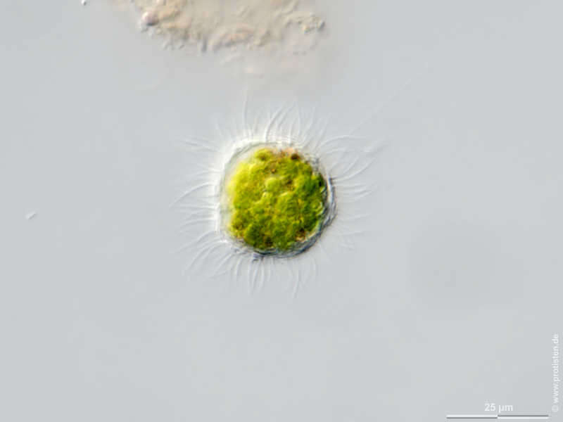
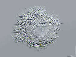
Choanocystis aculeata Scale bar indicates 25 µm. Sample from Kaltenhof Bog in the north of Kiel, Germany. Sampling date 9/2018. The image was built up using several photomicrographic frames with manual stacking technique. Images were taken using Zeiss Axioplan with Olympus OM-D M5 MKII. Image under Creative Commons License V 3.0 (CC BY-NC-SA). Place name: Bog Kaltenhof near Kiel (Schleswig-Holstein, Germany) Latitude: 54.42102744 Longitude: 10.07686615 Multiebenen-Abbildung, manuell gestapelt. Der Messbalken markiert eine Länge von 25 µm. Probe aus dem Kaltenhofer Moor nördlich von Kiel. Datum der Aufsammlung: 9/2018. Mikrotechnik: Zeiss Axioplan, Kamera: Olympus OM-D M5 MKII. Creative Commons License V 3.0 (CC BY-NC-SA). For permission to use of (high-resolution) images please contact postmaster@protisten.de.
-
Ribadelago, Castille and Leon, Spain
-
Villar del Pedroso, Extremadura, Spain
-
Transmission electron micrograph of a whole plate scale from the surface of a cell.